Processing And Storage Subsystem
The image formation from the radar echo of the SAR instrument involves a highly sophisticated processing effort. The main function of the processing and storage subsystem is to process and store the information obtained from the SAR instrument. The processing stages involves-
v Buffering of the SAR raw data stream in real-time
v Off-line image processing and compression of the buffered SAR data
v Mass memory data management and organisation
v Reformatting and output of compressed data at downlink rate
Rationale For On-Board Processing
Image from space under darkness or cloud cover can be obtained by flying a synthetic aperture radar on a satellite. As the satellite moves along its orbit ,the SAR looks out sideways from the directions of travel ,acquiring and storing the radar echoes which return from a strip of the earth's surface which is under observation.
Introduction
When a disaster occurs it is very important to grasp the situation as soon as possible. But it is very difficult to get the information from the ground because there are a lot of things, which prevent us from getting such important data such as clouds and volcanic eruptions. While using an optical sensor, large amount of data is shut out by such barriers. In such cases, Synthetic Aperture Radar or SAR is a very useful means to collect data even if the observation area is covered with obstacles or an observation is made at night at nighttime because SAR uses microwaves and the sensor itself radiates these. The SAR sensor can be installed in some satellite and the surface of the earth can be observed. The raw data collected by SAR are severely unfocussed and considerable processing is required to generate a focused image. The processing has traditionally been done on ground and a downlink with a high data rate is required. This is a time consuming process as well. The high data rate of the downlink can be reduced by using a SAR instrument with on-board processing.
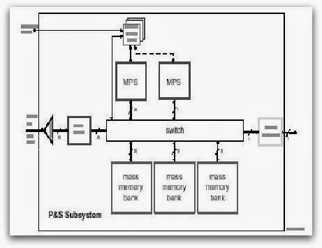
Processing And Storage Architecture
The architecture of the processing and storage subsystem is shown in fig 5. The digitised raw data enters the subsystem from the left. The data is assumed to consist of 16 bit complex samples, sampled at a rate which is higher than (20%)the chirp bandwidth. Hence it is assumed that the basebanding, demodulation and digitisation have taken place externally to this subsystem. Digital demodulation could also be performed within the subsystem. In this case, the input would consist of 8 bit real samples ,with twice the sampling rate as before. In the figure, the compressed output exits the subsystem at the right , through a number of t parallel channels.
Raw data compression with a BAQ type algorithm
The total range of data is target dependent and very high. Compared to this the instantaneous range is considerably less. This effect is used for lossy data reduction. If this technique is used on data in a transform domain, the properties of the instrument and the SAR processor can be used to achieve even better compression ratios. This technique can be combined with the data volume reduction of the over sampled data.
X-Band Sar Instrument Demonstrator
The X-band SAR instrument demonstrator forms the standardized part or basis for a future Synthetic Aperture Radar (SAR) instrument with active front- end. SAR is an active sensor. Active sensors carry on-board an instrument that sends a microwave pulse to the surface of the earth and register the reflections from the surface of the earth. Different sensor use different bands in the microwave regions of the electromagnetic spectrum for collecting data. In the X-band SAR instrument, the X-band is used for collecting data.
Abstract
Synthetic Aperture Radar or SAR is an imaging radar system that sends a microwave pulse to the surface of the earth and register the reflections from the earth's surface . On -board processing and compression of data obtained from the SAR is vital for image formation.
Conclusion
Synthetic Aperture Radar is now a well established part of radar art, both with airborne systems for surveillance and non-cooperative target identification purposes, and with space-borne systems for geophysical remote sensing applications over the oceans, land and polar regions.
No comments:
Post a Comment